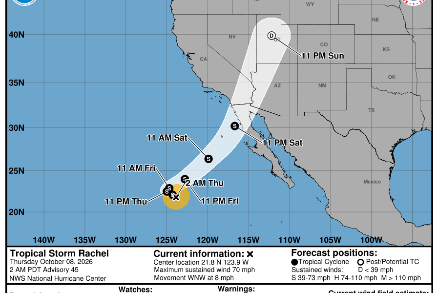

Quick answer (verified October 8, 2026, against the 2 a.m. PDT National Hurricane Center advisory): Rachel is now a tropical storm with maximum sustained winds of 70 mph, not a Category 1 hurricane. Its center was about 895 miles west of the southern tip of Baja California at 21.8°N, 123.9°W, moving west-northwest at 8 mph. The National Hurricane Center (NHC) reported no coastal tropical-storm or hurricane watches or warnings at that advisory time. However, a forecast turn toward northern Baja California and Southern California this weekend raises concerns about dangerous surf, rip currents and potentially heavy rainfall. Those risks do not require Rachel to reach the coast as a hurricane.
Important: These are time-stamped conditions, not live warnings. Check the NHC’s latest advisory and National Weather Service alerts for your exact location before changing travel plans or making safety decisions. The forecast track, intensity and timing can change with each update.
Tropical Storm Rachel status on October 8: The key facts
| Question | Official status at 2 a.m. PDT, Oct. 8 |
|---|---|
| Is Rachel still a hurricane? | No. NHC downgraded it to a tropical storm. |
| Maximum sustained wind | 70 mph (110 km/h), with higher gusts possible. |
| Center location | 21.8°N, 123.9°W, approximately 895 miles west of southern Baja California. |
| Direction and speed | West-northwest at 8 mph (13 km/h). |
| Minimum central pressure | 985 millibars. |
| Coastal hurricane or tropical-storm warnings | None in effect at the time of the advisory. |
| Most relevant coming days | October 10–11 for a possible northeastern approach and associated weather impacts. |
These figures come from NHC Public Advisory 45, issued at 2 a.m. PDT (09:00 UTC) on Thursday, October 8, 2026. Older stories calling Rachel a major hurricane describe a previous period of its life cycle; they should not be used as the current intensity.
Will Rachel hit California? What the forecast actually indicates
The NHC’s October 8 forecast discussion anticipates Rachel moving west-northwest in the short term before a turn to the northeast. The projected path then brings the weakening system toward northern Baja California and the southwestern United States over the weekend. Forecasters expect Rachel to weaken substantially and potentially become post-tropical as it moves inland. A projected track toward California is not a prediction of a California hurricane landfall.
Three details matter more than a single map line. First, a forecast cone represents uncertainty in the future position of the storm’s center, not the entire area that can experience wind or rain. Second, tropical moisture may spread beyond the forecast center. Third, steering currents and upper-level winds could still change Rachel’s exact approach or how quickly it weakens. Treat precise landfall-hour graphics shared on social media as provisional.
San Diego and northern Baja California
These areas are closer to the projected approach corridor. Beachgoers should pay particular attention to official rip-current and high-surf messaging. Residents should monitor local flood advisories if tropical moisture reaches the area. Border travel, ferry trips and beach activities can be affected by rough seas even when the strongest winds remain offshore or the system loses its tropical-storm designation.
Orange County and greater Los Angeles
Some forecast scenarios allow moisture or surf effects farther north, but an NHC center track toward the region does not establish that every Orange or Los Angeles County neighborhood will see tropical-storm-force winds. For those locations, check NWS Los Angeles/Oxnard and local alerts for rainfall totals, coastline statements and any flood products rather than assigning a county-wide impact from the cone alone.
Deserts, mountains and inland Southwest
Rain associated with a weakening tropical system can move far from the ocean. Terrain and dry washes can concentrate runoff, especially where heavy rain falls on hard, dry ground. Inland travelers should review localized flash-flood risk, road closure notices and canyon conditions before driving; the risk varies sharply by location and forecast timing.
Rachel forecast timeline: October 8 through October 12
This is a forecast scenario from the October 8 NHC discussion, not an observed future outcome. Updated bulletins may change the dates or projected intensity.
| Period | What forecasters are watching | What to do |
|---|---|---|
| Thursday, October 8 | Rachel has weakened to a tropical storm while moving west-northwest over the Pacific. | Check the latest NHC intensity estimate, not outdated hurricane headlines. |
| Friday, October 9 | Further weakening and an anticipated change in steering could set up a northeastward turn. | Monitor evolving NWS coastal and rainfall outlooks. |
| Saturday–Sunday, October 10–11 | The track may approach northern Baja California and Southern California, with dangerous surf and possible heavy rain. | Pay attention to beach safety alerts, local flooding forecasts and travel notices. |
| Monday, October 12 onward | Rachel may transition to a weaker or post-tropical system as it moves inland and dissipates. | Continue following rain and flood alerts even if the storm’s name disappears from headlines. |
There is no reliable basis in this advisory to promise a fixed rainfall total for an individual neighborhood or to label a specific airport as closed. Forecast weather is not an operational cancellation notice.
Is Southern California under a hurricane warning?
No, not under NHC Advisory 45. The agency explicitly stated that no coastal watches or warnings were in effect. This does not mean the weather will necessarily be harmless. Local offices can issue high-surf advisories, flood watches, flash-flood warnings or wind advisories as conditions develop; those are distinct products with different meanings and geographic boundaries.
If you are in San Diego County, use NWS San Diego to check hazards for your address. A warning for one county or stretch of coast should not be assumed to apply to every nearby beach or inland neighborhood.
Travel and beach safety: What residents and visitors can do
- Check conditions by location. Look up your city or ZIP code on Weather.gov and read any active local warning rather than relying solely on a national storm cone.
- Avoid dangerous surf and rip currents. A storm far offshore can still generate powerful waves and hazardous nearshore currents; obey lifeguards and beach-closure signs.
- Do not drive through floodwater. Flooded underpasses and desert washes can conceal strong flows and road damage. Turn around if a road is covered.
- For flights, check the airline directly. A weather forecast does not establish that an individual LAX, SAN, Tijuana or Los Cabos flight is canceled. Review the flight-status page and the airline’s waiver policy.
- For Mexico, follow local civil protection updates. Port and beach restrictions are controlled locally and can differ between northern Baja and the southern tourist corridor.
- Refresh official information repeatedly. This page is a snapshot; watches and warning boundaries can change several times a day.
Rachel, Simon and Isaias are different storms
Rachel is a named tropical cyclone in the eastern Pacific. AVARIXO separately covers Tropical Storm Simon’s Mexico forecast, another eastern Pacific system, and Hurricane Isaias in the Atlantic/Gulf region. Their advisories, forecast paths and warning areas must not be mixed. An alert for the northern Gulf Coast is not a California alert, and a Simon forecast map cannot be used to locate Rachel.
Frequently asked questions
Is Hurricane Rachel a tropical storm now?
Yes. NHC’s 2 a.m. PDT October 8 advisory downgraded Rachel to a tropical storm with 70 mph maximum sustained winds. Read newer advisories for subsequent changes.
Will Rachel make hurricane landfall in San Diego?
The October 8 NHC forecast does not establish that outcome. Rachel was weakening and may reach the general region as a weaker tropical or post-tropical system. Land impacts can occur without a hurricane landfall.
When could Rachel affect Baja California or Southern California?
The current forecast focuses attention on the weekend of October 10–11, but individual rain bands, waves and local warnings can develop at different times. Check the next NHC and NWS updates.
Are hurricane warnings in effect for California or Baja?
No coastal hurricane or tropical-storm watches or warnings were in effect under NHC Advisory 45, issued October 8 at 2 a.m. PDT. Local surf, wind or flood advisories are separate; verify the latest.
Does a storm cone show exactly where flooding will happen?
No. It estimates the likely future range of the storm center. Rainfall, ocean waves and flooding can extend beyond the cone, and local terrain affects flood risk.
Where is the most reliable live Rachel tracker?
Use the National Hurricane Center for the official storm position, cone and advisories, then use Weather.gov for city-level alerts.
Sources and last-verification note
This report was checked on October 8, 2026, using NHC Advisory 45 (09:00 UTC), the NHC forecast discussion for eastern Pacific storm EP182026, NHC’s official forecast products and NWS local alerts. The featured NOAA forecast map is a time-stamped October 8 snapshot, not a live-updating forecast. If a more recent official advisory differs, the newer advisory supersedes this article.