
Hurricane Isaias 2026: NHC Warnings, Storm Surge Zones & Landfall
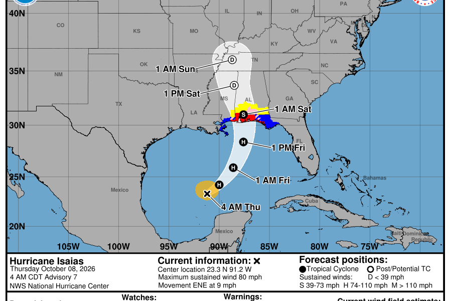
Quick answer (checked Thursday, October 8, 2026, around 4 a.m. CDT): Isaias is now a Category 1 hurricane over the Gulf of Mexico. The National Hurricane Center (NHC) confirmed 75 mph maximum sustained winds late Wednesday, and its latest overnight update keeps the system moving east-northeast toward the northern U.S. Gulf Coast. A Hurricane Warning is in effect from Ocean Springs, Mississippi, to the Bay/Gulf County line in Florida; the Storm Surge Warning extends from the mouth of the Mississippi River to the Steinhatchee River, Florida. Landfall is forecast within the warned coastal area late Friday, October 9, or early Saturday, October 10. Do not wait for the eye to arrive: flooding, tropical-storm-force winds and dangerous surf can begin earlier.
Safety-critical note: Hurricane forecasts, surge estimates, evacuation orders and local warning boundaries can change faster than this article can be updated. Always use the National Hurricane Center, your local National Weather Service forecast office, and your county’s emergency-management alerts for decisions. This is a timestamped explanation, not a live warning system.
Hurricane Isaias latest NHC status: October 8
| Key measure | Latest verified overnight status |
|---|---|
| Storm name | Hurricane Isaias, Atlantic basin, 2026 |
| Status | Category 1 hurricane, confirmed late October 7 |
| Maximum sustained wind | 75 mph (120 km/h), based on hurricane-hunter aircraft data |
| Overnight location | Near 23.1°N, 91.7°W at approximately 1 a.m. CDT October 8; about 445 miles south-southwest of the Mississippi River mouth |
| Movement | East-northeast at about 9 mph |
| Forecast landfall window | Late Friday, October 9, into early Saturday, October 10, subject to track and speed changes |
| Biggest immediate risks | Life-threatening storm surge, coastal inundation, damaging wind, heavy rain, flash flooding and dangerous surf |
The NHC’s mobile status feed reported Hurricane Isaias at 75 mph at 1 a.m. CDT on October 8, with a minimum central pressure near 981 millibars. The official NHC homepage and active storm graphics should be consulted for any advisory released after this check. The center’s position is not a map of every location that can experience severe conditions.
Where are hurricane, tropical storm and storm surge warnings in effect?
NHC’s overnight advisories upgraded large stretches of the northern Gulf Coast from watches to warnings. As of the October 7 10 p.m. CDT advisory, with Isaias upgraded to a hurricane at 10:30 p.m., the warnings included:
| Alert | Geographical extent reported by NHC | Meaning |
|---|---|---|
| Hurricane Warning | Ocean Springs, Mississippi, to the Bay/Gulf County line, Florida | Hurricane conditions are expected somewhere in the area, generally within 36 hours of first tropical-storm-force winds |
| Storm Surge Warning | Mouth of the Mississippi River to the Steinhatchee River, Florida | Danger of life-threatening inundation from rising water moving inland from the shoreline |
| Tropical Storm Warning (western side) | Jefferson/Plaquemines Parish line, Louisiana, to west of Ocean Springs, Mississippi | Tropical-storm conditions expected somewhere in the warned area |
| Tropical Storm Warning (eastern side) | East of Bay/Gulf County line to Aucilla River, Florida | Tropical-storm conditions expected somewhere in the warned area |
These boundaries are a snapshot, not guaranteed current alerts. Before acting, inspect the latest NHC public advisory and your local NWS warning map. A land location outside the hurricane-warning segment may still face flooding, severe rain, tornadoes or dangerous surf.
Florida Panhandle: Pensacola, Destin and Panama City
The western Florida Panhandle lies within a high-impact forecast corridor. The NWS Mobile/Pensacola office and NWS Tallahassee office provide county-level statements and local surge information. The local statement issued late Wednesday noted that hurricane and storm-surge warnings had replaced some watches along Northwest Florida’s coast. Residents in low-lying zones must monitor evacuation guidance from their county rather than treating the storm cone as an evacuation map.
Alabama coast: Mobile and Baldwin County
Mobile Bay and neighboring coastal communities are particularly exposed to surge driven inland by Gulf winds. Warnings cover coastal Alabama and can affect waterways well beyond beaches. Use Alabama Emergency Management Agency and NWS Mobile for locally appropriate instructions. Never drive through inundated roadways or attempt to outrun flooding after evacuation routes become unsafe.
Mississippi and southeast Louisiana
The Mississippi coast is included in the hurricane-warning area starting at Ocean Springs, while tropical-storm warnings extend west toward southeastern Louisiana. Storm surge warnings reach west to the Mississippi River mouth. Travelers and residents should also check Mississippi Emergency Management and Louisiana GOHSEP for local operational information. Exact impacts depend on the storm’s size and onshore wind direction, not only how close the center passes.
Storm surge forecast: why a hurricane’s category is not enough
Storm surge is water pushed inland by storm winds, often worsened by timing with the tide and by the geometry of bays or inlets. The NHC issued a warning for a broad coastal stretch because life-threatening inundation is possible. Earlier NHC guidance outlined elevated water levels reaching several feet above ground in vulnerable locations, including parts of Mississippi, Alabama and the Florida Panhandle. This article deliberately does not freeze a single maximum surge number for every town; levels differ sharply across short distances and may change with track shifts. View the NHC storm-surge resources and local inundation maps.
Floodwater is not the same as a large ocean wave. A home miles from an open beach can still be in a surge evacuation zone if connected to bays, rivers or low-lying channels. Local orders and official zone maps are more useful than a social-media image of the projected track.
When could Hurricane Isaias make landfall?
Current NHC guidance places the likely coastal crossing in the late-Friday or early-Saturday window. The precise landfall point remains uncertain within the forecast area. Strong winds and flooded roads may arrive ahead of the center, potentially complicating evacuation or airport travel on Friday. It is too early to promise that any specific city will be spared.
Does the forecast cone show the full danger area?
No. The cone describes uncertainty in the storm center’s future track. Damaging winds, storm surge, rainfall and tornadoes can extend beyond its outline. Small changes in the projected center can produce large changes in which bays receive the worst onshore push.
Will Isaias become a Category 2?
NHC says additional strengthening is expected through early Friday. Some forecast scenarios show a stronger hurricane before landfall, but its eventual category is not yet known. Residents should prepare for the hazards specified in active local warnings, not wait to see whether a category threshold is crossed.
Florida evacuations and state-of-emergency declarations
Florida has declared a state of emergency for 25 counties in anticipation of Isaias. A state of emergency is not itself an evacuation order. A mandatory evacuation, when issued, will identify the responsible jurisdiction and affected zones or populations. For the state order and what it means, see our Florida emergency declaration explainer. County emergency management is the source for whether your particular address is included.
As of Thursday morning, reporting also describes mandatory evacuations in parts of Florida’s Okaloosa County. Because local orders can be issued, revised or rescinded, residents should verify the text and zone directly with Florida Division of Emergency Management or the appropriate county agency. Do not make decisions solely from generic regional headlines.
Practical preparation before hazardous conditions arrive
- Verify your specific warnings. Search your ZIP code at Weather.gov, check county messages and turn on wireless emergency alerts.
- Know your evacuation zone and destination. Identify a route and alternative place to stay before weather deteriorates; follow mandatory orders.
- Prepare for power loss. Charge phones and medical devices, plan for backup power safely, stock prescribed medicines, water, food and essential supplies.
- Protect documents. Save insurance information, IDs and key contacts in waterproof packaging and accessible digital copies.
- Avoid surge and floodwater. Never drive across flooded roads; flooded zones may contain downed power lines and hidden hazards.
- Use generators only outdoors. Keep them well away from windows, doors and vents to reduce deadly carbon-monoxide risk.
For airline, school and business closures, rely on the operating organization rather than assuming that a hurricane warning automatically cancels a particular flight or event. If you are outside the coastal warning corridor, keep watching your local alerts because heavy rainfall may follow Isaias inland across the Southeast.
Is Isaias the first hurricane of the 2026 Atlantic season?
Yes. NHC confirmed its transition to hurricane strength at 10:30 p.m. CDT Wednesday, October 7, making it the first hurricane of an unusually quiet season. Several earlier named Atlantic storms had remained below hurricane intensity. Isaias’s unusual timing is meteorologically noteworthy but does not change individual preparation instructions.
Isaias is a distinct Atlantic storm from Tropical Storm Simon in the eastern Pacific, which has different forecasts and regional hazards.
Frequently asked questions
Is Hurricane Isaias currently a Category 1?
Yes, as of the NHC’s late October 7 and early October 8 updates, Isaias had 75 mph sustained winds. Its intensity may change; check the next NHC advisory.
Is Pensacola under a Hurricane Warning?
The NHC overnight warning extends from Ocean Springs, Mississippi, to the Bay/Gulf County line, Florida, including the Pensacola coastal region. Check NWS Mobile and local emergency management for address-level instructions.
Where could the worst storm surge occur?
Surge risk covers the NHC’s warned coastal corridor from the mouth of the Mississippi River to the Steinhatchee River. The worst flooding can vary by bay and coast orientation; use the latest official inundation maps and local evacuation notices.
Has Isaias already made landfall?
No, not as of this October 8 morning check. The NHC projects a northern Gulf Coast landfall late Friday or early Saturday; dangerous conditions can begin in advance.
Is a Hurricane Warning the same as a Hurricane Watch?
No. A watch means hurricane conditions are possible; a warning means they are expected within the applicable coastal area. The NHC upgraded portions of the Mississippi-to-Florida coast to warnings late October 7.
Where can I see Hurricane Isaias live?
Use the NHC storm dashboard, official track and warnings graphics and NWS local alerts. Forecast graphic snapshots embedded in articles can become outdated quickly.
Sources and update policy
Verified against the National Hurricane Center overnight October 8 status, the NHC’s hurricane update and coastal warning details, National Weather Service local products and independent Associated Press reporting. This article is a fixed-time explainer, not a substitute for the next storm advisory. The NHC advisory timestamp is more important than the article’s publication date when reviewing warning boundaries.
Featured map: National Hurricane Center, official Isaias forecast graphic (October 8, 2026 snapshot), hosted locally for AVARIXO. Graphic is not automatically updated after upload; consult NOAA for the latest map.

Other Articles
Valkyries vs Aces Game 3: Time, TV, Peacock & 2–0 Series