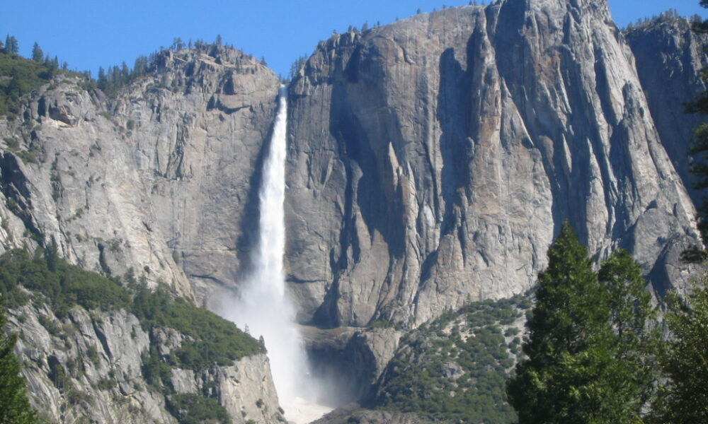

Quick answer (October 2026): The Upper Yosemite Falls hike is a strenuous, roughly 7.2-mile (11.6 km) round trip with 2,700 feet (823 m) of elevation gain to the top of Yosemite Falls. The National Park Service estimates six to eight hours for a full out-and-back day hike, starting near Camp 4 in Yosemite Valley. In October, the waterfall often carries very little water or may be dry, so choose the trail for its dramatic valley views rather than expecting spring’s roaring flow.
Upper Yosemite Falls trail at a glance
| Question | What to expect |
|---|---|
| Start | Yosemite Falls Trailhead behind Camp 4, near shuttle stop 7 |
| Hike to the top | Approximately 7.2 miles round trip |
| Elevation gain | About 2,700 ft (823 m) |
| Estimated time | 6–8 hours for most day-hike plans |
| Difficulty | Strenuous: steep grades, loose granite and many switchbacks |
| Shorter option | Columbia Rock, about 2 miles round trip and 1,000 ft climbing |
| Best waterfall flow | Usually spring into early summer, driven by snowmelt |
| Day-hike permit | Usually not required for the ordinary Yosemite Falls Trail day hike |
| 2026 park entrance reservation | Yosemite says no entrance reservation is required for 2026 |
Metrics are drawn from the official NPS Yosemite Falls Trail guide. Another Yosemite NPS trail index rounds the length to 7.4 miles; published distance estimates may differ slightly depending on measurement and turn-around location.
What is the hike to Upper Yosemite Falls like?
1. Camp 4 to Columbia Rock
The trail begins behind Camp 4 near Yosemite Valley. Steep switchbacks climb through wooded slopes and exposed sections of granite. Columbia Rock is a useful goal for hikers who want elevated views of the Valley without spending the day climbing to the top. NPS lists the out-and-back as about two miles with 1,000 feet of ascent, typically taking two to three hours.
2. Columbia Rock toward the waterfall viewpoint
Continuing past Columbia Rock brings changing views of the waterfall and nearby cliffs. The route is not simply a steady, flat traverse: hikers encounter additional climbing and areas of loose, eroded granite. Weather can make the upper sections slippery even when the Valley floor seems mild.
3. Upper switchbacks to the top
The final climb is very steep and rocky, with little room for error beside exposed slopes. At the top, designated viewpoints overlook Yosemite Valley and the place where Yosemite Creek drops over the cliff. Stay on maintained trails and use built platforms only; the waterfall lip is not a safe place for a shortcut or photograph.
Upper Yosemite Fall vs Lower Yosemite Fall
| Feature | Upper Yosemite Falls Trail | Lower Yosemite Fall area |
|---|---|---|
| Main goal | Reach the top of the waterfall and high viewpoints | Easy valley-floor view of the falls |
| Effort | Long strenuous uphill hike | Much shorter paved visitor route |
| Equipment | Supportive footwear, day-hike kit, water and layers | Comfortable walking shoes generally sufficient |
| Best for | Experienced hikers with sufficient daylight and fitness | Visitors with limited time and groups wanting a low-effort waterfall view |
The waterfall’s overall measured height is around 2,425 feet (739 meters) across its cascades. That figure is the combined falls’ height, not the exact trail’s climbing height; the trail involves roughly 2,700 feet of total ascent.
Is Upper Yosemite Falls dry in October?
It often is. Yosemite Falls is primarily fed by melting snow. The NPS fall guide warns that Yosemite Falls can carry little or no water in October and November. Early storms sometimes restore flow, but they also introduce wet rock, colder temperatures and potential snow or ice at higher elevations.
If the point of your trip is to photograph an active waterfall, check the official current-conditions page and a live Yosemite Falls webcam where available. A spring photo in an older article is not evidence of how the falls looks on your specific travel date.
What should you bring for the full hike?
- Water and food: take enough for a six-to-eight-hour day; do not rely on seasonal trickles as a water supply.
- Good traction: loose granite and steep sections make casual sandals a poor choice.
- Layers: temperatures and wind differ sharply between Valley floor and rim.
- Navigation and emergency plan: save park maps offline and tell someone your intended route.
- Early start: short October daylight and slower descents matter as much as the ascent.
- Sun protection: sections of the switchbacks are exposed.
- Weather check: snow, ice, thunderstorms, smoke and rockfall may make a hike unsafe on a given day.
Do you need a reservation for Yosemite Falls Trail in 2026?
For an ordinary day hike to the top of Yosemite Falls, NPS does not list a separate trail permit requirement. Yosemite also states that a reservation is not required to enter the park in 2026. However, an entrance fee or valid park pass can still apply, and overnight backpacking requires a wilderness permit. Never confuse no entrance reservation with free entrance or unlimited overnight camping.
Five mistakes to avoid
- Starting the full ascent at noon and underestimating the return time.
- Expecting the waterfall to run at spring strength in fall.
- Going beyond a barrier to reach a dramatic photograph.
- Assuming a Valley floor temperature forecast describes the conditions on the upper trail.
- Using an outdated map or relying on a route that is temporarily closed.
Frequently asked questions
How hard is the hike to Upper Yosemite Falls?
Strenuous. NPS lists approximately 2,700 feet of climbing and a six-to-eight-hour full round trip.
Can beginners hike to Columbia Rock?
Columbia Rock is a shorter alternative, but the climb still gains about 1,000 feet and can be difficult for unprepared visitors.
How long is Upper Yosemite Falls Trail?
Official NPS descriptions generally give about 7.2 miles round trip to the top. Route estimates may differ slightly between mapping sources.
Are dogs allowed on the Upper Yosemite Falls Trail?
No. NPS prohibits pets on this hiking trail and most natural-surface Yosemite trails. Service-animal rules differ from pet rules.
Can you hike it in winter?
The route may be accessible in some winters but upper sections can be dangerously icy or buried by snow. Assess actual conditions and experience before attempting it.
When is the best time for flowing water?
Typically May or early June, depending on that year’s snowpack and temperatures.
Checked October 2026. Sources: NPS Yosemite Falls Trail, Yosemite fall season guidance, 2026 reservations and permits.