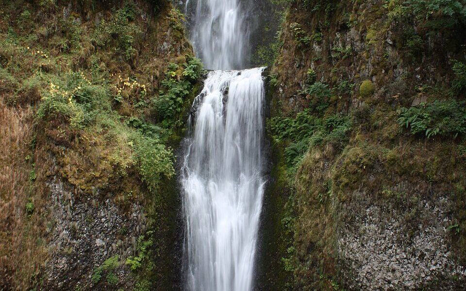

Quick answer, updated October 13, 2026: Multnomah Falls Recreation Area is a year-round day-use destination in Oregon’s Columbia River Gorge, roughly 30 miles east of Portland. It features the 620-foot Multnomah Falls, a lower viewing plaza, historic Benson Bridge, Multnomah Falls Lodge and the steep Larch Mountain Trail toward the upper overlook. In 2026, the I-84 Exit 31 timed-entry requirement ran from May 22 through September 7, between 9 a.m. and 6 p.m. That season has ended as of this article’s update; do not buy a timed permit for an October 2026 visit. Check the next season’s rules before traveling in 2027. Parking remains limited even when permits are not required.
The U.S. Forest Service currently lists the site as open, but says the lodge’s regular restrooms are closed for renovation through November 2026 and that a limited number of portable toilets are available. This article separates current access facts from seasonal requirements so you can plan the right trip rather than following old parking advice.

Where is Multnomah Falls Recreation Area?
The recreation area is on the Oregon side of the Columbia River Gorge, east of Portland and west of Hood River. The Forest Service provides GPS coordinates of approximately 45.575893, -122.128025. Multnomah Falls is not inside a national park; it belongs to the Columbia River Gorge National Scenic Area managed by the U.S. Forest Service. You can generally visit the lower falls without committing to the steep hike to the upper overlook.
The main access for many drivers is Interstate 84, Exit 31, where a large free lot serves the waterfall. Visitors walk under the highway and railroad tracks, then toward the historic lodge. A second, smaller privately operated paid parking area near the lodge is accessible from the Historic Columbia River Highway (U.S. 30). Check current road conditions before choosing a route because the scenic highway is occasionally affected by construction or landslides.
Official destination information: U.S. Forest Service — Multnomah Falls.
Multnomah Falls 2026 permits: what is required now?
This is the most important planning detail if you have read pages that say a reservation is always required. In 2026, the I-84 Exit 31 timed-use system applied only within specified dates and hours:
| Access question | 2026 official rule | What it means for visitors |
|---|---|---|
| Dates | May 22 to September 7, 2026 | The listed 2026 permit season has ended as of October 13 |
| Daily hours during that season | 9:00 a.m. to 6:00 p.m. | Timed permits applied to I-84 vehicle access during this window |
| Vehicle access covered | I-84 Exit 31 parking lot | One permit per private vehicle; it did not reserve a parking space |
| Historic Highway/U.S. 30 lot | No 2026 timed permit required through that entrance | Small privately operated fee lot; parking still may be full |
| Public transit | 2026 timed permit not required | Check operating schedules and fares with the transport provider |
| 2027 permit system | Not confirmed in this article | Recheck the official pages when next season is announced |
Sources: Recreation.gov: Multnomah Falls I-84 Timed Use Permit and the Forest Service site page. The permit page also notes that bookings were released in two waves, 14 days and two days ahead, during the 2026 season. Those reservation windows are historical by October 2026, not evidence of a currently active requirement.
Does an I-84 permit guarantee a parking space?
No. Recreation.gov explicitly says the timed-use permit did not reserve a parking space. The Exit 31 lot can fill and barriers may close the entrance. The right strategy is to check conditions before setting off, allow extra travel time, and have a backup plan. During future permit seasons, an assigned time is a window to arrive, not a guaranteed slot to park.
Do you have to pay to see the waterfall?
Do not confuse access, parking and timed-entry reservation fees. The Forest Service identifies the I-84 Exit 31 lot as free parking; the privately operated Historic Highway lot charges for parking. During the 2026 timed-entry season, Recreation.gov required a permit for eligible I-84 arrivals and displayed its own reservation fee. Check official listings before paying, especially because the 2026 timed-entry dates have passed.
Parking at Multnomah Falls: which lot should you use?
Option 1: I-84 Exit 31 — the main lot
The large public parking area at Exit 31 is the Forest Service’s main recommended parking location. From Portland, use I-84 eastbound. From the Cascade Locks side, use I-84 westbound. The exit ramp is on the left, so follow highway signs rather than making a sudden lane change. A walkway connects the lot to the lodge and falls; follow signs and cross roads only at designated places.
Even outside permit season, expect congestion. The Forest Service says the entrance closes automatically when the lot is full. Do not stop on I-84, block a shoulder or queue illegally for a space. Oregon’s TripCheck provides highway and traffic information; the permit page directs visitors to camera views for the Multnomah Falls parking area.
Option 2: Historic Columbia River Highway lot
The small lot along U.S. 30 in front of Multnomah Falls Lodge is privately operated and paid. It includes a limited number of accessible spaces. Because spaces are scarce, this should not be treated as guaranteed overflow parking. Check highway repair notices, access direction and on-site signage. The Forest Service prohibits stopping or obstructing Historic Highway 30 when trying to park.
Option 3: Arrive without a car
The Columbia Gorge Express connects Portland-area transit with stops including Troutdale, Multnomah Falls, Cascade Locks and Hood River. The Forest Service lists daily service, but individual departure times and costs may change. Check the operator’s live schedule before relying on a particular trip, and confirm your return ride before beginning a longer hike.
Visitors can also consider authorized sightseeing shuttles. Do not assume a commercial tour is included in the price of any government parking permit: shuttle tickets and timed-use permits are separate products.
What can you see without hiking?
From the main visitor area, you can enjoy the waterfall from the lower viewing plaza and see Benson Bridge arching between its tiers. The Forest Service describes the lodge and lower viewing area as wheelchair-accessible, with a paved route from the main parking lot, although there are mild slopes. This is the best plan if someone in your group cannot handle a long uphill walk.
Multnomah Falls drops approximately 620 feet in two stages. Its flow is fed by underground springs near Larch Mountain and commonly looks stronger in winter and spring. A wet-weather visit can be beautiful, but mist, slick surfaces and falling debris demand care. Viewing conditions vary; photographs from other seasons are not a guarantee of what the water will look like that day.
Three realistic walking and hiking options
Different websites give different mileage because they describe different endpoints. There is a meaningful distinction between the plaza, the bridge and the upper overlook. Choose your turnaround point based on ability and trail conditions.
| Route | Effort | What you see | What to know |
|---|---|---|---|
| Main plaza and lodge | Short paved walk from parking | Classic lower view of waterfall, lodge and bridge | Some inclines; lower viewing area is accessible |
| Lodge to Benson Bridge | Short but steeper uphill walk | Closer view between the two waterfall tiers | Paved, sometimes wet and crowded; follow closures |
| Lodge to upper falls overlook and back | Strenuous hike | Elevated views and the top of the falls | Forest Service lists 2.4 miles round trip and about 600 feet elevation gain |
The official Forest Service page specifies 2.4 miles out and back to the upper viewpoint, around 600 feet of climbing, and calls the terrain steep and uneven. That is not the mileage for merely visiting the lower plaza. The path beyond Benson Bridge is more demanding than many casual visitors expect.
Is the Benson Bridge walk worth it?
For people comfortable with a short uphill path, Benson Bridge provides the waterfall’s most recognizable middle-tier vantage point. Mist can make the bridge and approaches slippery. The crossing may be crowded at peak times; allow others to pass and never climb barriers for a photo. If a closure sign blocks access, do not attempt an alternative scramble up the cliff.
Can beginners hike to the top?
Some beginners with adequate footwear and fitness can manage it, but the upper overlook is a steep hike, not a casual extension of the wheelchair-accessible plaza. The Forest Service compares the climb to about 60 flights of stairs and recommends hiking essentials. If you are tired at Benson Bridge, it is completely reasonable to turn around there.
What should you know about the lodge and facilities in October 2026?
Multnomah Falls Lodge has a visitor center, refreshments, shopping and a restaurant. Service hours can vary and should be checked directly. At the time of this update, the U.S. Forest Service flags restrooms closed for renovations through November 2026, with limited portable toilets on-site. This is an important consideration if you are traveling with young children or people who need reliable restroom access.
Water and picnic options are described on the Forest Service site, but availability and maintenance can change. Carry water, especially if you plan to hike. The lower plaza is a better place to decide whether everyone feels comfortable continuing uphill than making that decision later on the steep trail.
When is the best time to visit Multnomah Falls?
There is no single best month: conditions change throughout the year. The waterfall generally has higher flow in winter and spring; peak travel months are likely to bring more parking pressure. Consider these practical trade-offs:
| Season | Potential upside | What to watch |
|---|---|---|
| Winter | Often strong water flow, dramatic mist | Ice and winter travel hazards; check closures |
| Spring | Green surroundings, substantial water flow | Rain, slippery trails and busy weekends |
| Summer | Long daylight hours for Gorge exploration | Full parking; during 2026, timed-entry rules ran May 22–September 7 |
| Autumn | Changing leaves, after the listed summer permit season | Early sunset, rain, construction and rapidly changing conditions |
If you are visiting from Portland for only a few hours, prioritize the main waterfall and lodge rather than committing to multiple strenuous Gorge hikes without checking conditions. A backup stop in the area can keep your day enjoyable when Exit 31 parking fills.
Accessibility, children, pets and safety rules
Is the main viewing area accessible?
The Forest Service says the lodge and lower viewing plaza are wheelchair-accessible, and identifies accessible parking and a paved approach. Slopes still exist. Benson Bridge and the upper overlook should not be assumed wheelchair-accessible simply because the entrance plaza is.
Can you bring a dog?
Dogs are allowed in designated areas with leashes and control according to the Forest Service; keep pets leashed in parking areas, the plaza and on the paved path. Bring supplies to clean up after them. Consider whether a crowded, wet uphill route is suitable for your pet.
Are bicycles and drones allowed?
The site’s Forest Service rules prohibit bikes, e-bikes, scooters, skates and skateboards in the managed recreation area, and prohibit aircraft and drone takeoffs or landings. Stay on marked paths, pack out trash and do not disturb spawning fish in Multnomah Creek.
Can you stop for a quick roadside photo?
Do not stop on I-84 shoulders or obstruct Highway 30. Enter a legal parking area or choose a lawful transit option. The waterfall is highly photographed, but roads and nearby rail tracks are not safe pedestrian photo platforms.
A simple half-day plan from Portland
- Before leaving: Check the Forest Service status, TripCheck, and any Gorge closures or access alerts. Confirm whether your date falls within any announced reservation season.
- Choose transport: Drive to I-84 Exit 31 only if parking is likely feasible, or plan a specific transit arrival and return. Have an alternative stop if the lot is full.
- Begin at the lower plaza: Take in the falls from the accessible viewing area; check current facility availability.
- Continue to Benson Bridge if appropriate: Wear shoes that grip on wet surfaces and keep children close on the steeper paved sections.
- Decide on the upper overlook: Only continue if your group is prepared for approximately 2.4 miles round trip and around 600 feet of climbing.
- Leave no trace: Return on the marked path and take belongings and litter out with you.
This plan does not assume a specific driving time, live parking availability or an open trail segment. Those variables require a day-of-visit check.
Common mistakes to avoid at Multnomah Falls
- Using an old permit guide as if its dates apply forever. The 2026 permit period ended on September 7; watch for a new announcement instead of guessing 2027 rules.
- Assuming a permit reserves parking. It never guaranteed a space.
- Confusing the lower plaza with the upper overlook. The latter is a real hike with significant elevation gain.
- Driving to the small U.S. 30 lot without a backup. That fee lot has limited capacity, and highway construction can change access.
- Assuming the regular restroom facilities are open. As of October 13, 2026, renovation through November is explicitly noted by the Forest Service.
- Following outdated shuttle or lodge schedules. Confirm the operator’s current times and return arrangements.
Multnomah Falls Recreation Area FAQs
Is Multnomah Falls open year-round?
The Forest Service lists the site as year-round day use and currently reports it open, but weather, hazards, construction and maintenance can temporarily restrict particular facilities or trails.
Do I need a reservation for Multnomah Falls in October 2026?
The published 2026 I-84 timed-entry season ended September 7, so that seasonal permit requirement does not cover an October 2026 visit. Parking availability and other safety restrictions still apply; check official alerts immediately before departure.
Can I get to Multnomah Falls without a car?
Yes. The Columbia Gorge Express and some commercial shuttles serve the falls. Check the operator’s current routes, fares and return departures rather than assuming the service runs at a particular hour.
How high is Multnomah Falls?
The Forest Service gives a height of 620 feet for the combined waterfall.
How long is the hike to the top?
The official Forest Service description lists 2.4 miles round trip with about 600 feet of elevation gain to the upper overlook and back. You do not need to do that full hike to see the falls from the lower plaza.
Is Benson Bridge the same as the top of the falls?
No. Benson Bridge crosses between the waterfall’s two major sections. The upper overlook requires additional climbing after the bridge.
Is parking at Multnomah Falls free?
The large I-84 Exit 31 parking area is free according to the Forest Service, subject to seasonal access rules. The small Historic Highway lot at the lodge is privately operated and charges a parking fee.
Are the bathrooms open in October 2026?
The Forest Service says regular restrooms are closed for renovation through November 2026, with a limited number of portable toilets available. Verify any updates on the official site before visiting.
Can you take photos of the waterfall?
Yes from lawful visitor viewpoints. The Forest Service prohibits drone takeoffs and landings on-site and requires visitors to remain on designated paths. Never climb barriers or stop on a highway for photography.
Browse other destination explainers and travel planning guides in the AVARIXO Travel section.
Sources and photo licensing
- USDA Forest Service — Multnomah Falls Recreation Site: location, year-round designation, current 2026 restroom alert, main lot, trail distance, elevation, accessibility and safety.
- Recreation.gov — Multnomah Falls (I-84) Timed Use Permit: exact May 22–September 7, 2026 permit dates, hours, access restrictions and parking caveat.
- Ready, Set, GOrge!: planning, car-free transit and Gorge access alerts.
- Jessicacu — Multnomah Falls Oregon.JPG, Wikimedia Commons: the historical illustrative photograph used above is released into the public domain by the photographer. It is not an AVARIXO-owned photograph, and it does not depict live 2026 conditions.
Last editorial update: October 13, 2026. Dates and descriptions reflect published agency guidance available at the time; road, trail, parking and facility conditions should always be checked again on your travel date.

Other Articles

Firefox Private Browsing (2026): Incognito Mode on PC and Phone