Quick answer (checked October 14, 2026): El Morro National Monument in western New Mexico is free to enter. Its visitor center and hiking trails are currently open daily, 9 a.m.–5 p.m. Mountain Time, through October 17. On October 18, 2026, the winter schedule begins: Thursday through Monday, 9 a.m.–5 p.m., with no Tuesday or Wednesday trail access. Start the 0.75-mile Inscription Loop by 4 p.m. or the 2-mile Headland Trail by 2:30 p.m. Restoration work has closed part of the Headland Trail, so check its current route with a ranger before setting out.
El Morro is more than a sandstone landmark. A dependable water pool at the base of the cliff drew ancestral Puebloan communities, Spanish travelers, and later American emigrants. You can see ancient petroglyphs, centuries-old inscriptions, and, when accessible, remains of Atsinna Pueblo on the bluff above. This guide separates what is open today from what might be closed, explains the two walks, and gives realistic itineraries instead of assuming every trail section is accessible.
El Morro National Monument at a glance
| Question | 2026 answer |
|---|---|
| Where is it? | Highway 53 near Ramah, western New Mexico; about 42 miles south/west from Grants via the signed route |
| Entrance charge | Free; no entry ticket or national parks pass needed |
| Visitor center and trail hours, through Oct. 17 | 9 a.m.–5 p.m. Mountain Time, seven days/week |
| Winter hours, starting Oct. 18 | 9 a.m.–5 p.m. Thursday–Monday; closed Tuesday and Wednesday |
| Inscription Rock Trail | 0.75-mile loop; allow roughly 45 minutes; last start 4 p.m. |
| Headland Trail | 2 miles, moderately strenuous; allow about 2 hours; last start 2:30 p.m.; partial closure in effect |
| Camping | Free nine-site campground, first come, first served; no reservations |
| Before travel | Ask NPS about trail work/weather: 505-783-4226 ext. 801 |
Timing matters: A park page with old seasonal information can mislead you about which weekdays are open. Use the current NPS hours and current conditions notice, especially if you are visiting after October 17 or after recent rain or snow.
What is special about El Morro?
The monument protects a tall sandstone headland called Inscription Rock and a historic pool below it. The water made this a natural stopping point along a difficult cross-country route. People left markings for very different reasons across many centuries. Some petroglyphs came from ancestral Puebloan cultures. Later Spanish inscriptions record names, dates, and travel accounts. American travelers also left inscriptions before the practice was halted to protect the resource.
Look carefully: these are not modern decorative carvings or a blank wall on which visitors may sign their names. The NPS describes more than 2,000 historic inscriptions and petroglyphs across the site. Respect barriers, do not touch or trace marks, and do not add new writing. Even gentle handling can degrade sandstone and irreplaceable cultural features.
What is Atsinna Pueblo?
Atsinna is an ancestral Puebloan settlement high on the headland, dating from about 1275 CE. The National Park Service describes a once-substantial community whose surviving masonry provides a connection to Indigenous peoples and the Zuni homeland. Some archaeological sections can be viewed from the Headland Trail when its route is accessible. The monument is a living cultural landscape, not simply an abandoned ruin or roadside photo stop.
Inscription Rock Trail vs. Headland Trail: which hike should you choose?
| Feature | Inscription Rock Trail | Headland Trail |
|---|---|---|
| Length | 0.75 mile (1.2 km) | 2 miles (about 3.2 km), including the lower trail |
| Typical time | About 45 minutes | About 2 hours |
| Main sights | Historic water pool, inscriptions, petroglyphs | All lower sights plus bluff views and Atsinna area, when accessible |
| Terrain | Mostly paved; grades in places | Rocky and uneven sandstone, elevation gain and steps or switchbacks |
| Latest permitted start | 4 p.m. | 2:30 p.m. |
| Current caution | Open only during monument operating hours | Southern portion closed for restoration; confirm permitted route |
Choose the Inscription Rock Trail for a shorter visit
This is the best introduction if you have an hour, are traveling with children, or want to focus on the pool and inscriptions without climbing onto the mesa. Borrow or obtain the self-guided trail material at the visitor center, if available, to identify the carvings. The main paved half-mile section can be wheelchair-accessible with assistance, but the uphill and downhill grades mean conditions and individual mobility matter; ask the visitor center about the precise route before going.
Choose the Headland Trail for a bigger hike—if the route is open
The longer walk climbs onto the sandstone and offers broad views and access toward the Atsinna Pueblo area. Expect rocky footing and a more demanding return than the lower loop. The current NPS alert reports a closure of the south portion during restoration; the remaining permitted route or turnaround may differ from the usual full loop. Do not bypass closures, and do not assume a posted two-mile loop description guarantees a through-hike on your date.
Take shoes with secure grip, carry drinking water, and build in extra time for viewing stops. On the day, rangers—not an older travel blog—are the best source of guidance about safe access.
What you will actually see: cliff, pool and 1709 inscription
The cliff’s weathered surface carries visible human history. An inscription from 1709 was carved by Ramón García Jurado, according to the U.S. Geological Survey, which documents this specific carving. The historical water pool and several other inscriptions lie along the lower route.
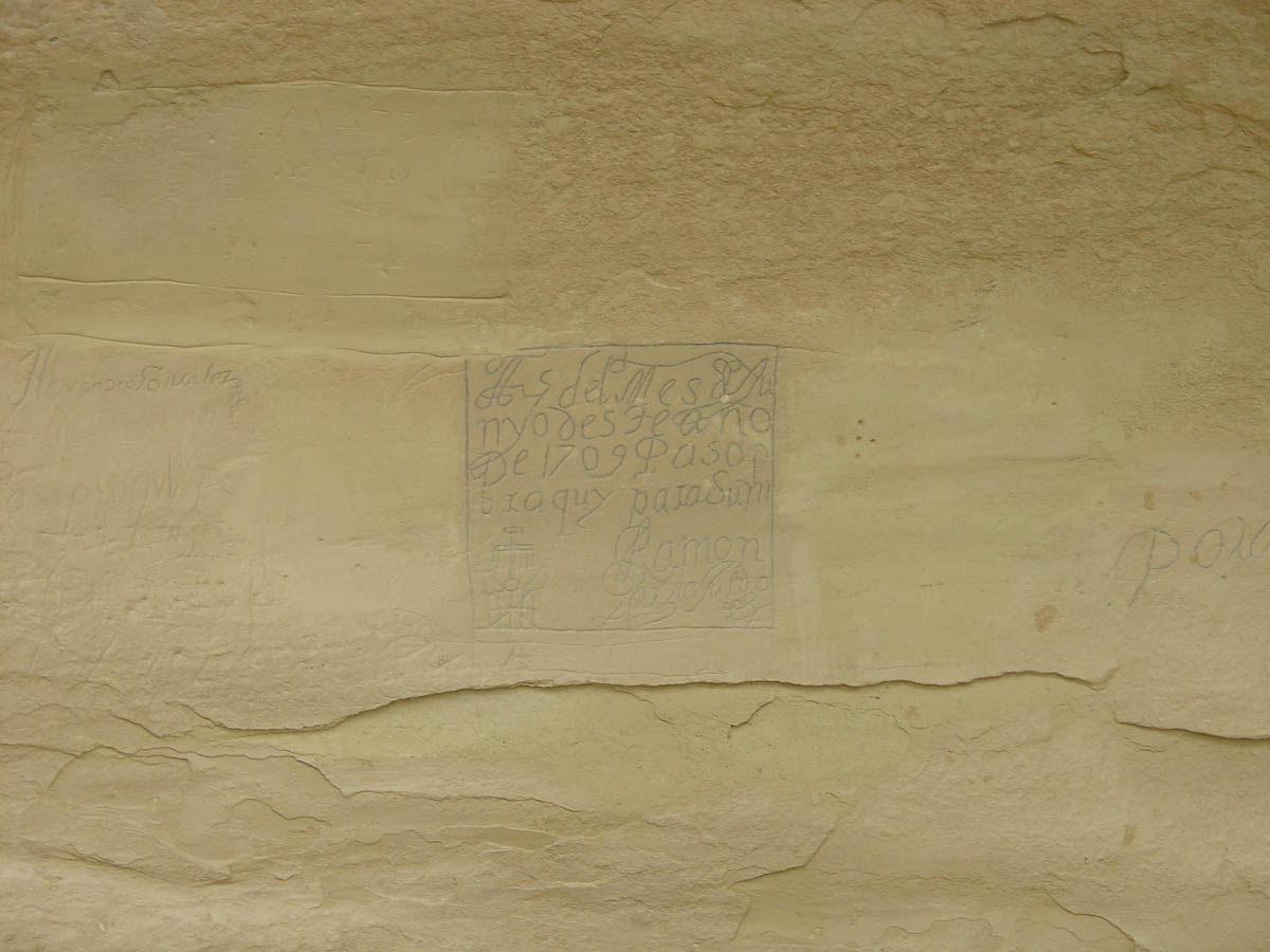
There is a compelling contrast here: the inscriptions are not all from one period, and the water pool’s role changed across generations. In the site’s deeper history, the ancestral Puebloan story predates the Spanish and American marks; the trail is most meaningful when you recognize all three layers rather than focusing only on travelers’ names.
2026 opening hours: the October change you must know
Through Saturday, October 17, 2026: The visitor center and park trails operate every day from 9 a.m. to 5 p.m. MT. From Sunday, October 18, 2026 through May 27, 2027: NPS lists Thursday–Monday, 9 a.m. to 5 p.m., with closures on Tuesdays and Wednesdays. Park trails cannot be entered outside the visitor center’s operating hours.
NPS also lists closures for Thanksgiving, December 25, and January 1. Posted alerts and weather may override regular hours, and winter ice can shut sections of the Headland Trail. The park’s official conditions page currently flags restoration work on the southern trail portion. The 2:30 p.m. Headland cutoff and 4 p.m. lower-loop cutoff are more useful for planning than simply knowing that the visitor center closes at 5 p.m.
Where is El Morro and how do you get there?
The physical address is Mile Marker 44.6, Highway 53, Ramah, NM 87321. From Albuquerque or the east, follow Interstate 40 to Grants, exit 81, and drive south/west on Highway 53 for about 42 miles, following park signs. From the west, the park’s directions route travelers from Gallup via Highway 602 and Highway 53. Do not rely solely on a generic “El Morro” map pin: there are other landmarks and businesses with similar names.
Plan for a remote high-desert drive. Fuel, food and cellphone coverage are not things to take for granted immediately beside the monument. Download maps before departure. The NPS notes no public visitor Wi-Fi at El Morro and intermittent or nonexistent cellular coverage in parts of the area. Check weather even if nearby towns are sunny; elevation and local storms can change trail conditions quickly.
Free camping at El Morro: nine sites, no booking
According to the NPS campground information, the monument has nine fee-free campsites, open year-round on a first-come, first-served basis. You cannot reserve a pitch in advance. Sites include a gravel tent pad, picnic table and a ground grill. Two vault toilets serve the area, and water at campground spigots is seasonal: it is shut off when freezing nights begin.
There are no RV hookups, and NPS lists a maximum RV length of 27 feet overall. The campground remains accessible at night, but camping there does not grant after-hours access to the monument’s hiking trails. Check fire restrictions and campground rules before lighting a grill. Have a backup camping plan if arriving late on a busy weekend.
Suggested itineraries for 45 minutes, two hours or half a day
If you have about 45–60 minutes
Begin at the visitor center at 9 a.m. or soon after. Ask whether the Inscription Trail is open; then walk its 0.75-mile loop, stopping at the pool and significant carvings. Leave time to return comfortably rather than walking up against the closure window.
If you have roughly two hours
First ask a ranger what sections of the Headland Trail are accessible under restoration work. If enough of the route is open, make the bluff hike your main activity. If access is restricted, use the Inscription Loop and spend the balance of your time in the visitor center exhibits. Plan the long hike before early afternoon.
If you have half a day
Allow a slow pace, look at the exhibits, study the inscriptions and visit the longer trail only if permitted. Bring a packed meal for the designated picnic area rather than assuming there is a restaurant inside the monument. For a broader Southwest heritage-focused journey, our separate Tonto National Monument guide explains a different ancestral cliff-dwelling visit in Arizona; the sites are not close enough to combine casually on a short El Morro stop.
What to bring and what not to do
- Carry water: Do not treat the historic pool as a drinking-water source. Bring enough for the length of your walk and the season.
- Wear stable shoes: Upper-trail rock can be uneven and slippery when wet or icy.
- Dress for elevation: El Morro stands at roughly 7,200 feet; mornings and winter days can be cold even in the Southwest.
- Stay on legal paths: Historic inscriptions and archaeological fabric are fragile. Never scratch, trace, touch or climb over protective barriers.
- Respect the clock: Trails are not open for sunset or nighttime hikes merely because you are camping nearby.
- Check pet and access rules: Leashed pets are permitted on designated trail routes under NPS rules, but clean up and keep animals under control. Ask staff about route accessibility if walking or mobility is limited.
Frequently asked questions
Does El Morro National Monument cost money?
No. The monument is fee-free year-round, and its nine-site campground does not charge a camping fee. A third-party site that still advertises a per-person entrance price is not consistent with the park’s current official information.
Is El Morro open on Tuesdays?
Yes through October 17, 2026, under summer hours. From October 18, 2026 through May 27, 2027, the posted winter schedule closes the visitor center and trails on Tuesdays and Wednesdays.
How long does it take to see the inscriptions?
Allow approximately 45 minutes for the 0.75-mile Inscription Rock Trail, longer if you want to study individual carvings or move at a slower pace. Start no later than 4 p.m.
Can you walk the complete Headland Trail in October 2026?
Do not assume so. As checked October 14, NPS reports the south portion closed for restoration. Call 505-783-4226 ext. 801 for the current permitted route and any weather-related closure.
Is El Morro the same as El Malpais National Monument?
No. They are separate National Park Service sites in western New Mexico. El Morro is known for its water pool, historic inscriptions and Atsinna Pueblo; El Malpais protects extensive volcanic landscapes.
Can you visit after the park closes if you are camping?
No. The campground is open at night, but the visitor center and park trails are not accessible outside posted operating hours.
Last fact check: October 14, 2026. For live conditions, visit the official NPS El Morro conditions, NPS opening-hours page, and NPS trail information before traveling. Hours, restoration access and campground water service may change.