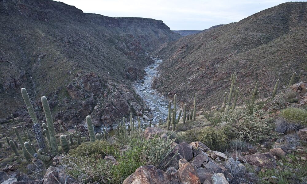

Quick answer — checked October 14, 2026: Agua Fria National Monument in central Arizona is free to enter and open around the clock, but it is not a developed park with a staffed entrance, paved sightseeing loop, drinking-water stations, or reliable cell coverage. The easiest first visit is generally the Badger Springs access point off Interstate 17. Pueblo La Plata and longer segments of Bloody Basin Road are better suited to visitors prepared for rough roads and remote desert travel. Always check conditions with the Bureau of Land Management (BLM) before leaving the highway.
Agua Fria National Monument at a glance
| Visitor question | Practical answer |
|---|---|
| Where is it? | Central Arizona, about 40 miles north of central Phoenix, with access from Interstate 17. |
| Entrance fee | No general entrance fee. |
| Opening hours | Open 24 hours, year-round; conditions and specific routes can change. |
| Best months for a first trip | Usually fall and spring, when daytime heat is more manageable. |
| Water | No potable water supplied inside the monument; bring all you need. |
| Cell signal | Limited and unreliable in remote areas. |
| Camping | Dispersed camping generally allowed; BLM lists a 14-day stay limit. |
| Main challenge | Choosing an access route suited to your vehicle and the weather. |
Those are general BLM rules, not a guarantee that a particular dirt road or wash is passable today. Call the Hassayampa Field Office at 602-867-5400 for current information. The official Agua Fria visitor page is the starting point for directions, rules and closures.
Which entrance should you take? Three distinct trip options
There is no single entrance gate that serves every part of the monument. Pick your access point based on what you want to see rather than entering “Agua Fria National Monument” into navigation and accepting the first pin.
| Access point | Best for | Road and trail reality |
|---|---|---|
| Badger Springs Road, I-17 Exit 256 | First-time hikers, river scenery, a short exploration on foot | Gravel approach to the trailhead, then sandy and rocky terrain; assess conditions after rain. |
| Bloody Basin Road, I-17 Exit 259 | Longer scenic driving, mesas and remote cultural sites including Pueblo La Plata | BLM says its first five miles are graded; rougher sections beyond may need high clearance or four-wheel drive. |
| Cordes Lakes / 3M Ranch area, near I-17 Exit 262 | Riverbend Recreation Area and historical home-site visits | Less-developed northern routes; confirm access and vehicle suitability before setting off. |
Practical choice: If you have an ordinary car and only a few hours, begin by evaluating Badger Springs. If your goal is Pueblo La Plata, do not assume a sedan can reach it just because a map draws a route. If rain is forecast or the ground is muddy, postpone backcountry driving; dry-looking washes can still become hazardous when water runs off from storms upstream.
Badger Springs Trail: the best starting point for many visitors
BLM identifies Badger Springs Trailhead as a popular entry into the monument. From the parking area, visitors walk the wash toward the confluence with the Agua Fria River, where prehistoric rock art can be found. This is a desert wash walk, not a landscaped promenade. Footing can vary between soft sand, gravel and rock, and route finding becomes harder when visitors stray into side drainages.
How to plan a low-stress Badger Springs visit
- Leave Interstate 17 at Exit 256 and approach the trailhead on Badger Springs Road only if conditions permit.
- Before walking, photograph the trailhead information and save an offline map; mobile coverage cannot be assumed.
- Carry drinking water and protect yourself from sun even for a short outing. Turn around early if footing or weather worsens.
- Follow the wash toward the river. Keep a close eye on landmarks for the return.
- View rock art without touching, wetting, tracing or rubbing carved surfaces; leave pottery and stone objects exactly where found.
Trail distances vary across guide descriptions, and unmarked wanderings can be much longer than the intended short excursion. Plan time using daylight, conditions and your group’s pace rather than treating an approximate mileage from an app as a guarantee.
Petroglyphs: what the protected rock art actually looks like
The petroglyphs are part of a broader landscape of Indigenous history. They are not replicas installed for tourists. The image below shows actual engraved rock surfaces at Agua Fria National Monument, photographed by BLM personnel—not an illustration or a scene from a different park.

Rock art is vulnerable to oils from hands, scratches, climbing and unauthorized marking. Enjoy it from a respectful distance; keep pets controlled and avoid exposing sensitive archaeological locations through off-trail shortcuts. BLM asks all visitors to leave archaeological artifacts in place.
Pueblo La Plata: a more demanding cultural-site trip
Pueblo La Plata preserves low walls of an ancestral village on a mesa. Reaching it can involve a high-clearance road followed by walking over rough ground. The landscape is open and visually dramatic, but it does not offer the level of interpretation or accessible paths that a developed museum might provide.
For a Pueblo La Plata outing, verify the approach road, travel with adequate fuel, carry an offline route and allow considerable time for the return. Do not drive around ruts or road obstacles through vegetation: motor vehicles must stay on numbered, designated roads. Stay off ruin walls and keep all cultural objects undisturbed. If you do not have a suitable vehicle, make this a future trip rather than improvising an unsafe approach.
Bloody Basin Road: scenic drive, not an ordinary highway
Bloody Basin Road is one of the monument’s best-known backcountry corridors, but its condition changes. BLM describes the first five miles as graded; farther out, high clearance may be necessary and four-wheel drive can be prudent. A vehicle advertised as an SUV is not automatically appropriate: tires, ground clearance, driver experience and recent storms all matter.
Before attempting the longer road
- Ask BLM about recent washouts, closures and whether the specific segment you plan to use is passable.
- Load your map offline and tell someone which route you plan to take and when you expect to return.
- Start with a full fuel tank, drinking water, a spare tire in usable condition and appropriate repair supplies.
- Stay on legally designated roads. Never make a shortcut through a wash, grassland or archaeological site.
- Turn back before road conditions exceed your vehicle’s abilities; a destination is not worth a recovery emergency.
Camping at Agua Fria National Monument
BLM permits primitive, dispersed camping in appropriate parts of the monument, with a general 14-day stay limit. That does not mean every roadside pullout is an approved campsite. Use previously disturbed or hardened sites when possible, avoid fragile riverbanks, observe current fire restrictions and pack out every piece of waste. Recreation.gov advises camping at least 200 feet from water sources to protect riparian habitats. Do not expect a developed campground, reservations, running water or hookups inside the monument.
For your first overnight visit, review the BLM rules, camping limitations and weather forecast with the same care you would give a long backcountry hike. Bring more water than the bare minimum, extra clothing for temperature swings, headlamps and an appropriate waste-disposal plan. A vehicle parked in a dry wash can be dangerous during a flash flood even when rain is not falling directly overhead.
When to visit: October conditions versus summer heat
Fall and spring generally give visitors more comfortable temperatures than the exposed summer months. BLM warns that summer temperatures can exceed 110°F. October may be more pleasant for walking, but it does not remove the risks of dehydration, uneven terrain, sudden rain or limited rescue access.
| Season | What changes for visitors | Recommended approach |
|---|---|---|
| Spring | Often milder, with seasonal wildlife and vegetation | Begin hikes early; check forecasts and watch for snakes. |
| Summer | Dangerous daytime heat; storms may trigger flash floods | Avoid demanding midday hiking and unnecessary remote driving. |
| Fall | Generally more comfortable days, with variable storm risk | Good time for a cautious first visit; verify road conditions. |
| Winter | Cooler days, colder nights and possibly slick unpaved roads | Bring layers and do not enter muddy backcountry roads. |
Can you bring a dog?
BLM permits pets at Agua Fria, but owners must keep them under control and clean up waste. Carry separate drinking water for your dog, protect paws from sharp rock and hot ground, and keep animals from archaeological features and wildlife. A desert hike is not a good place to discover that an animal cannot safely manage rough terrain or exposure.
Agua Fria versus Tonto National Monument
Both are in Arizona, but they offer quite different experiences. Agua Fria is largely an open, minimally developed backcountry landscape with dispersed cultural sites and variable road conditions. Tonto National Monument, by contrast, has a visitor center and a defined route to its Lower Cliff Dwelling; its separate upper tour may be restricted by alerts. Choose Agua Fria for remote exploration and scenery, or Tonto if your priority is a more structured archaeological visit. Check the conditions of whichever monument you plan to visit.
One-day Agua Fria itinerary for first-time visitors
Morning: Check the BLM visitor page, contact the field office if there has been recent rain, confirm the Badger Springs approach and fill your water bottles before leaving the Phoenix area. Drive to the trailhead and assess the conditions on arrival.
Late morning: Walk into Badger Springs Wash at a pace that allows plenty of time to return, view river scenery and look for rock art without touching or disturbing it. Spend time photographing broad landscapes rather than searching for unmarked archaeological sites.
Afternoon: Return to your car before heat, fatigue or a weather change become problems. If you have a second destination in mind, do not tack a remote Bloody Basin excursion onto the same trip without checking driving time and road access. A relaxed first visit is safer than an overambitious checklist.
Frequently asked questions
Is Agua Fria National Monument free?
Yes. BLM lists no general entrance fee. Special permits may still be needed for certain organized uses or large groups.
Does Agua Fria have a visitor center?
Do not plan around a developed visitor-center experience. The monument has very limited facilities, and visitors should be self-sufficient. BLM lists vault toilets at Badger Springs Trailhead and Silver Creek, but no available drinking water.
Can I drive through with a regular car?
Some approaches may be manageable in suitable conditions, but you should not assume every backcountry road is sedan-friendly. The rougher reaches of Bloody Basin Road may require high clearance or four-wheel drive, and wet weather can make even shorter approaches unsafe.
How far is Agua Fria from Phoenix?
BLM places the monument about 40 miles north of central Phoenix. Driving time depends on your specific access point, traffic, road conditions and whether you continue on unpaved roads.
Is there cell service or water?
Do not rely on cell service and do not expect drinking water inside the monument. Bring an offline map, ample water and a check-in plan with someone at home.
Can I take home pottery fragments?
No. Leave pottery, stones, rock art and all historical materials undisturbed. Their location is part of the archaeological record.
Official resources used to verify this guide
Visitor information reviewed October 14, 2026. Check current road and weather conditions before visiting: BLM Agua Fria National Monument visitor guide; Recreation.gov Agua Fria gateway. The BLM Hassayampa Field Office can be reached at 602-867-5400. This guide does not claim a field visit, a personally driven route or real-time road verification.

Other Articles

Sakura Stand Codes (October 2026): KCTVChannel, zahando and More
Freestyle Swimming Technique: 6 Fixes and a 25-Minute Pool Plan
