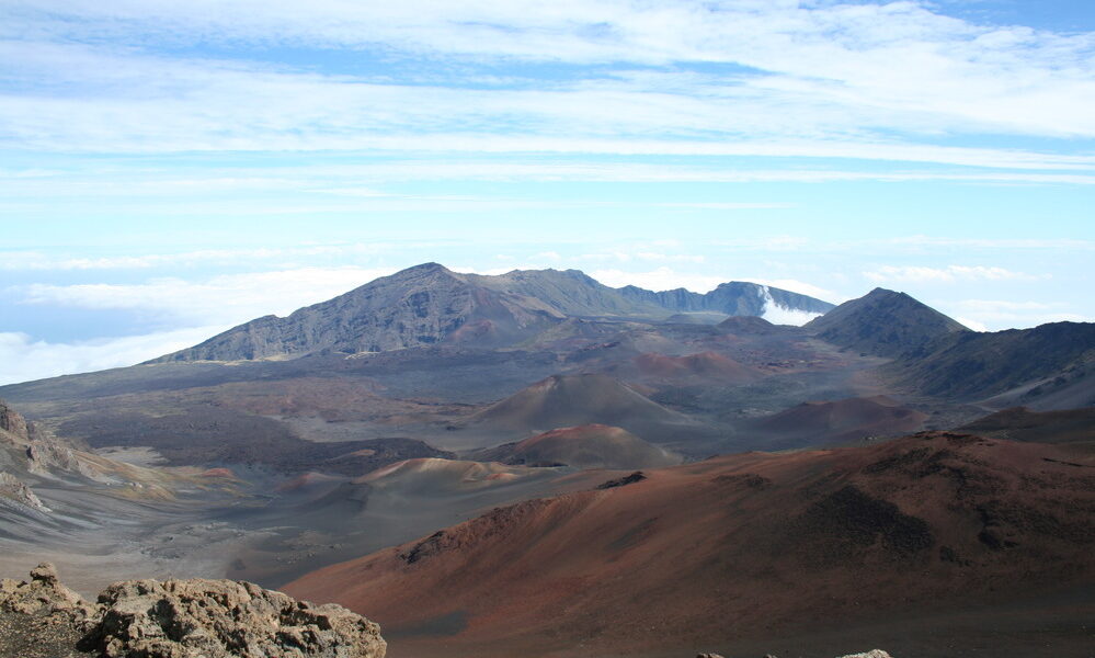

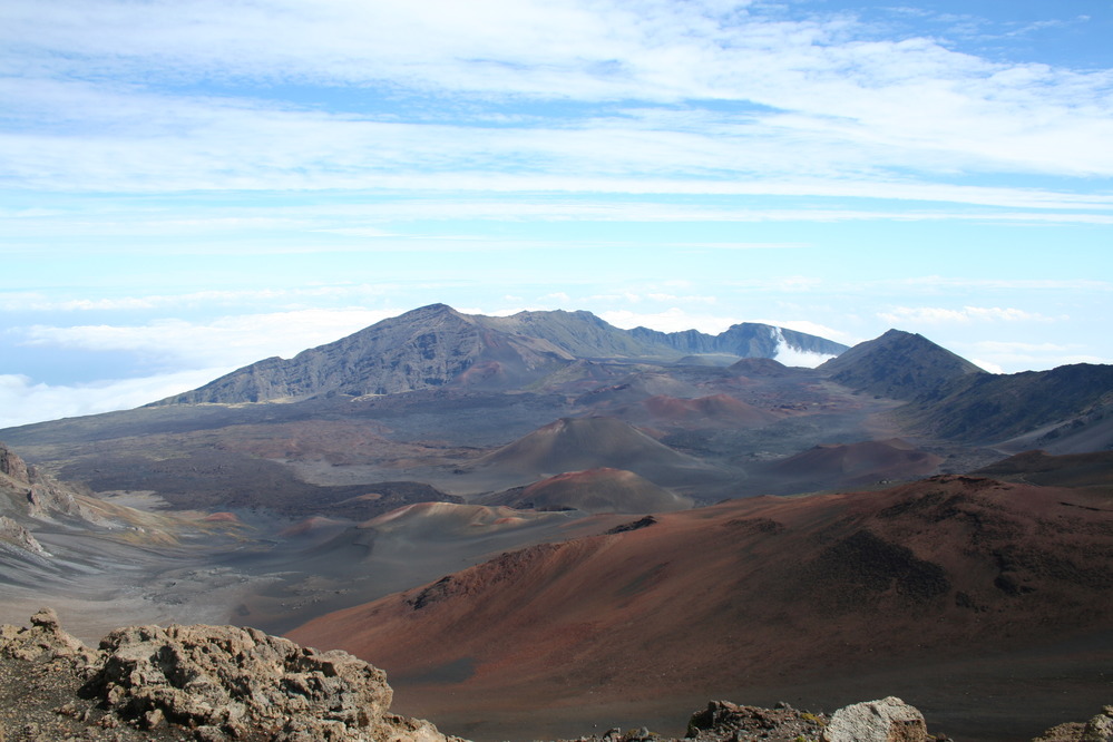
Quick answer (October 2026): The vast red-and-brown depression at the summit of Haleakalā National Park on Maui is commonly called Haleakalā Crater, although park geologists describe it as a largely erosion-shaped volcanic valley rather than a classic collapse caldera. You can see it from summit overlooks without a long hike. Sunrise entry from 3–7 a.m. requires a separate advance reservation; daytime viewing normally does not.
Haleakalā Crater: quick facts
| Visitor question | Answer |
|---|---|
| Island and park | Maui, Haleakalā National Park Summit District |
| Summit height | 10,023 feet (3,055 meters) |
| Best quick view | Haleakalā Visitor Center overlooks |
| Short lookout trail | Pā Kaʻoao: around 0.4 mile round trip |
| Sliding Sands short option | First overlook: around 0.5 mile round trip |
| Crater floor | Around 3.9 miles one way, with a substantial climb back |
| Sunrise reservation | Required for entry from 3–7 a.m.; $1 per vehicle in addition to entrance fee |
| Private-vehicle entrance | $30, valid for three days under the current schedule |
Is Haleakalā Crater a real volcanic crater?
The enormous colorful depression visible from Haleakalā’s summit is traditionally called Haleakalā Crater, but the National Park Service explains that it is not a conventional volcanic crater or a caldera formed by a single explosive collapse. Water erosion helped carve two major valleys, Koʻolau Gap and Kaupō Gap, into the volcanic mountain. Later volcanic activity partly refilled those valleys with cinder and lava deposits, creating the extraordinary landscape visitors now see. The result is a broad basin with red, brown and gray cinder cones. Understanding this geology makes a visit more rewarding: the landscape records both destructive erosion and renewed volcanic activity rather than just one ancient eruption.
Where the crater is and how to reach it
Haleakalā National Park lies on the island of Maui, Hawaii. The Summit District is accessed by driving uphill from central Maui toward the park’s entrance and high-elevation visitor areas. The summit reaches 10,023 feet (3,055 meters), but the main Haleakalā Visitor Center overlooks the depression from roughly 9,740 feet. The lower coastal Kīpahulu District belongs to the same national park but is not connected to the summit by an internal driving road. Navigate specifically to the Summit District for crater views. Do not simply search for the park name and assume the first result leads to the lookout you want.
The quickest ways to see the crater without a full-day hike
You do not have to cross the entire volcanic basin to get a remarkable view. The area next to the Haleakalā Visitor Center looks out across the colorful cinder landscape, and the nearby Pā Kaʻoao path offers a short walk toward another perspective. The National Park Service lists Pā Kaʻoao as approximately 0.4 mile round-trip with about 100 feet of climbing. Kalahaku and Leleiwi Overlooks offer different sightlines and can be worthwhile as conditions change. Visibility is never guaranteed: fast-moving clouds can fill the basin, especially when trade winds push moisture against the mountain. Plan some flexibility rather than expecting every viewpoint to be clear simultaneously.
Sliding Sands Trail: start small before committing
The Keoneheʻeheʻe Trail, often called Sliding Sands, begins near the Haleakalā Visitor Center parking area and descends into the volcanic landscape. The NPS lists its first overlook at roughly 0.5 mile round-trip, with a relatively modest 50-foot elevation change for that short portion. Beyond the overlook, the trail becomes a significantly more demanding undertaking. Reaching the floor of the basin involves about 3.9 miles one way and nearly 2,500 feet of elevation change. Because you descend first, the most tiring uphill segment comes when you return. Plan turnaround times around your fitness, daylight, altitude and water, not merely the trail’s easy-looking opening.
Crossing the basin is a full-day plan, not a casual shortcut
Experienced hikers sometimes combine Sliding Sands with the Halemauʻu Trail for an approximately 11-mile route ending well below the first trailhead. This is a point-to-point hike, and the National Park Service does not operate a hiker shuttle that returns walkers to their starting vehicles. Arrange transportation responsibly and check the current trail map before setting out. Weather can change quickly, and the high altitude adds difficulty even on apparently gradual terrain. If your trip mainly involves sightseeing rather than serious hiking, a short out-and-back from the visitor center will be more practical than trying to reproduce a demanding cross-basin itinerary.
Sunrise needs a separate reservation
A sunrise drive into the Summit District requires an advance vehicle reservation for access between 3:00 a.m. and 7:00 a.m. Hawaiian Standard Time. The reservation costs $1 per vehicle and is separate from the national park entrance fee. The official system releases some reservations up to 60 days ahead, with an additional batch about two days before the visit; the National Park Service says walk-up or phone reservations are not offered. Book through Recreation.gov, keep the confirmation and have the named reservation holder’s identification ready. A sunrise ticket applies to its stated date only. A standard park pass by itself is not a substitute for that early-morning reservation.
Can you visit Haleakalā for sunset without the sunrise ticket?
The special sunrise reservation is not normally required for arriving outside the 3:00–7:00 a.m. entrance window. Sunset viewing does not currently have an equivalent reservation system, according to the park’s official FAQ. However, sunset is popular and parking can fill. A park alert warns that vehicles may be temporarily turned around at the summit entrance when capacity is reached; the NPS suggests arriving well in advance. Bring a warm layer even if you have spent the afternoon on a tropical beach. Clouds can make a dramatic sunset, but they can also obscure most of the crater with little warning.
Fees, passes and reservations are three different things
The standard Haleakalā National Park entrance fee for a private vehicle is $30, and its three-day validity covers both the Summit and Kīpahulu Districts. Individual visitors arriving without a vehicle and motorcycles have different fee rules, and eligible federal passes may cover ordinary entrance charges. The early sunrise reservation is an additional $1 vehicle booking rather than another park entrance ticket. Do not pay a third-party seller for a supposed guaranteed sunrise slot. The park describes cashless fee collection, so prepare a supported payment card or a valid pass before arriving. Review current prices on the park website rather than a social-media screenshot.
What October 2026 visitors should check
An alert posted in January 2026 described limited parking and traffic delays near Haleakalā Visitor Center due to a water-infrastructure project. The park also warns about busy sunrise and sunset access, rapidly shifting weather and fragile native species along roadsides. These are conditions to check just before your visit, not a promise that every day will have identical delays. The summit area remains high, exposed and remote. There is no gas station within the park, so fill the tank in town. Download navigation details before driving uphill and leave room in your schedule if construction, clouds or parking change your original plans.
Cold, thin air is an underestimated hazard
At more than 9,000 feet, the air contains less oxygen than at sea level and vigorous hiking may feel harder than expected. The NPS identifies shortness of breath, headache, nausea and dizziness among possible altitude-related symptoms. Stop and reassess if you feel unwell; descending and seeking appropriate medical attention can be more important than reaching an overlook. Strong sunlight, low temperatures, wind and rapid cloud changes can occur within the same visit. Carry water, layers, sun protection and sturdy shoes. For longer hikes, turn around early enough to avoid ascending exhausted after dark. Children and visitors with heart or respiratory concerns should plan conservatively.
How to photograph the real landscape respectfully
For natural photographs, first wait for cloud breaks and position yourself along established overlooks or approved trails. The cinder cones and ridgelines can be more impressive in side lighting, but avoid stepping off route to reach a slightly different angle. Haleakalā is a sacred landscape for Native Hawaiians as well as a protected national park. Leave rocks, plants and cultural features undisturbed; silversword plants have fragile root systems. Avoid making images look like active lava eruptions if that is not what you actually saw. Our own related guide to Crater Lake’s Wizard Island explains a contrasting volcanic basin with a very different visitor experience.
A realistic half-day summit itinerary
Begin with a weather and condition check, then enter the Summit District with sufficient fuel, water and warm clothing. Stop at the visitor center to orient yourself and look across Haleakalā’s erosional basin. If visibility allows, explore the short Pā Kaʻoao path or walk the first safe portion of Sliding Sands; do not go farther just because the outbound route descends easily. Continue to a different overlook for a changing perspective, and leave time for the road back down. Sunrise requires special preparation and a reservation, while an ordinary daytime visit is a flexible alternative. The official NPS hiking guide, current alerts, and fees and reservations page should be checked before departure.
Frequently asked questions
Is Haleakalā Crater an active lava lake?
No. The colorful basin visitors see is a cinder-and-lava landscape shaped by erosion and volcanic activity, not a currently bubbling lava lake.
Do you need a reservation for ordinary daytime crater views?
Not normally for ordinary daytime entry. The special vehicle reservation covers the sunrise entry period of 3–7 a.m.; standard park fees still apply.
How long does it take to hike into the crater?
A brief walk reaches a viewpoint, but reaching the valley floor is much more strenuous: about 3.9 miles downhill one way and an uphill return with significant elevation gain.
Can you drive from the crater to Kīpahulu within the park?
No. The Summit and Kīpahulu Districts are not directly connected by an internal park road.
Can you visit if it is cloudy?
Yes, although crater views may be obscured. Check weather and webcams, and never continue a dangerous hike solely to wait for a photograph.