
Quick answer (October 15, 2026): Newberry Crater is the broad, roughly 4-by-5-mile volcanic caldera at the summit of Newberry Volcano in central Oregon, inside Newberry National Volcanic Monument. It contains Paulina Lake, East Lake, the Big Obsidian Flow and viewpoints from Paulina Peak. It is not the same place as Crater Lake National Park. Summer is the simplest time to visit by car; in October, check the Deschutes National Forest for road, trail and visitor-facility status before setting off, because high-elevation access is seasonal.
Newberry Crater: the essential visitor facts
| Question | Practical answer |
|---|---|
| What is Newberry Crater? | A caldera (collapsed volcanic summit), not a small impact crater. |
| Where is it? | Central Oregon, southeast of Bend and east of La Pine, within Deschutes National Forest. |
| Main sights | Paulina Lake, East Lake, Big Obsidian Flow, Paulina Falls and Paulina Peak. |
| Best general season | Summer into early fall, when upper roads and visitor services are more likely to be available. |
| Can you drive there? | In the normal operating season, yes via the Paulina–East Lake Road approach from the US 97 corridor, subject to weather and closures. |
| Does every location use the same entrance? | No. The caldera, Lava Lands/Lava Butte and Lava Cast Forest are separate areas of the larger monument. |
| Does access require a fee? | Some developed Forest Service day-use sites require a recreation pass, and cave, shuttle or campground services can have separate charges or reservation rules. Confirm the site you intend to use. |
Geology note: The U.S. Geological Survey (USGS) dates the present caldera to a major explosive collapse about 75,000 years ago, whereas the youngest Big Obsidian Flow formed around 1,300 years ago. Those are two different events—do not confuse the volcano’s age with the lava flow’s age. See the USGS caldera explanation.
What should you see inside Newberry Crater?
1. Paulina Lake: the western crater lake
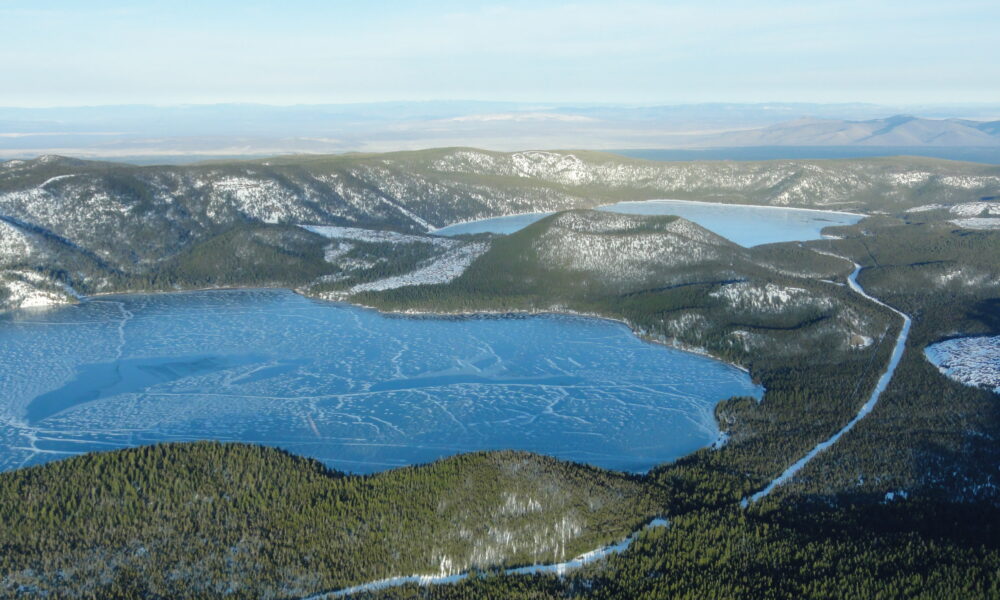
Paulina Lake fills much of the caldera’s western basin and is framed by forest and volcanic slopes. It is the easiest focal point for understanding the landscape: from a suitable viewpoint you can see how the lake fits into the broad collapse depression rather than a steep, conical crater. Established day-use access, a lakeshore trail and seasonal camping are among the area’s draws, though the status of individual facilities can differ.
The Forest Service recreation listings provide separate entries for Paulina Lake day use, boating and campgrounds. A developed campground being closed for the season does not automatically mean every nearby trail or lakeshore viewpoint is closed. Check the exact facility.
2. East Lake: a different lake in the same caldera
East Lake lies east of Paulina Lake, separated by volcanic terrain including the Central Pumice Cone. USGS aerial photographs show both lakes within the same caldera. Visitors sometimes assume a single lake with two names; they are separate bodies of water with distinct access points, shores and services. Look up the destination on your map before driving, rather than relying only on the broad label “Newberry Crater.”
Access for boating, fishing and camping depends on seasonal operations, road conditions and any relevant state requirements. Check Oregon Department of Fish and Wildlife rules before fishing; access to a lake is not a substitute for a valid license and current regulations.
3. Big Obsidian Flow: volcanic glass made visible
The Big Obsidian Flow is Newberry’s youngest lava flow, approximately 1,300 years old. Obsidian is natural volcanic glass that forms as silica-rich lava cools rapidly. Its dark, jagged surfaces contrast sharply with the surrounding forest and pumice. The Forest Service describes an approximately one-mile interpretive trail across the flow area, but trailhead status can change seasonally.
Stay on the established route, wear sturdy footwear and do not collect rocks or volcanic glass. The material can have sharp edges, and preserving geological features is part of visiting a protected monument. If the Forest Service recreation database shows the trailhead as closed, choose another stop rather than walking past barriers. The USGS Big Obsidian Flow feature explains the eruption sequence.
4. Paulina Peak: the classic overlook
Paulina Peak rises to about 7,984 feet and offers an elevated look across the caldera and its lakes on clear days. The summit road is seasonal and should never be assumed open simply because US 97 is clear. Check Forest Service road and snow reports before attempting to drive up. If the summit is inaccessible, a lake-level visit or another open overlook is a reasonable fallback.
5. Paulina Falls: a short stop outside the lake basin
Paulina Creek leaves Paulina Lake and descends at Paulina Falls, west of the caldera’s main lake area. It is a useful shorter stop on a driving itinerary, especially for travellers who do not want to undertake a full crater-rim hike. The Forest Service describes the falls area as a double waterfall roughly 80 feet high, with an overlook and nearby trails. Verify trail and parking conditions on your chosen date.
Newberry Crater vs Lava Lands vs Lava Cast Forest
These attractions share one national volcanic monument, but they are not one compact park entrance. This distinction matters if you have only a few hours and are using a map application.
| Area | What you will see | Planning point |
|---|---|---|
| Newberry Caldera / Newberry Crater | Paulina Lake, East Lake, Paulina Peak, Big Obsidian Flow | High elevation; vehicle access and facilities are seasonal. |
| Lava Lands / Lava Butte | Cinder cone, lava landscapes, visitor-center interpretation | Separate area nearer Bend/Sunriver; shuttle and center hours vary by season. |
| Lava River Cave | A lava tube you can explore when officially open | Seasonal opening, reservation and bat-protection requirements; never enter when closed. |
| Lava Cast Forest | Ancient lava impressions of trees, short interpretive walk | Separate access road and road-surface considerations. |
The Deschutes National Forest site groups these places under the larger monument, while the USGS monument overview explains their shared volcanic origins. A visit to one area does not mean the others are necessarily close or open.
How to reach Newberry Crater from Bend or La Pine
For the summit caldera, plan your route toward Paulina Lake and East Lake from the US 97 corridor, using the signed access from the La Pine area. Do not accidentally navigate to Lava Lands Visitor Center, which is a separate portion of the monument, and assume the lakes are immediately behind it.
- Check the Forest Service’s current Deschutes conditions and alerts before leaving. Forest roads, visitor centers and campgrounds have separate status updates.
- Choose one specific destination—Paulina Lake Day Use, Big Obsidian Flow, Paulina Falls, East Lake or Paulina Peak—rather than navigating to “Newberry National Volcanic Monument” generically.
- Check for a developed-site pass, any campground or cave reservation, weather, daylight and road suitability for your vehicle.
- Carry offline directions, water, layers and a backup destination. Cell reception and staffed visitor services cannot be relied upon throughout the area.
Late-season caution: Sources describing “open May–October” mean a typical operating window, not a promise that roads remain passable on every October day. The 2025 Forest Service Volcanic Vistas guide describes many high-country facilities as usually closing in September or October and notes that dates are subject to change. That guide is historical context, not a verified 2026 opening notice.
Can you visit Newberry Crater in October 2026?
Possibly, but do not assume the full summer experience is available. October can bring freezing nights, early snow, changing forest-road conditions, closed visitor desks and the end of campground services. The caldera itself remains a real landscape, while access to a particular trailhead or road may be limited. The distinction between the monument’s boundary and staffed operating facilities is essential.
On a current Forest Service recreation listing, individual sites such as Lava River Cave, Lava Lands Visitor Center and some campgrounds can be marked closed. These notices should be checked directly on the day of travel rather than treated as a complete, permanent closure of Newberry Crater. If you see a gate, obey it; do not infer that a historic guide overrides a current closure.
Should you visit Lava River Cave in October?
Do not plan an October cave visit unless the Forest Service explicitly announces an applicable opening. The Forest Service’s published seasonal guide describes Lava River Cave as typically closing in mid-September, in part for seasonal protection of bat populations. The cave is not an always-open roadside attraction, and online tourism summaries may repeat summer information long after their season ends.
Are recreation passes required?
A pass may be needed at designated Forest Service recreation-fee sites. Pass requirements and prices depend on the site and current rules; vehicle parking passes do not automatically cover every reservation, shuttle fare or special service. Review the official forest recreation-pass information for the exact place you intend to stop. A paid campground reservation is also separate from a day-use pass where one is required.
One-day Newberry Crater itinerary
Option A: summer or confirmed-open early fall
- Morning: begin with Paulina Lake and take time to identify the caldera’s shape from an accessible lakeside viewpoint.
- Midday: continue to East Lake or the Big Obsidian Flow interpretive area if that trail is open. Allow more time than the listed trail distance suggests for slow footing on uneven volcanic surfaces.
- Afternoon: drive to Paulina Falls and, if road conditions permit, Paulina Peak. Do not force the summit road into the itinerary if it has closed.
- Before dark: leave the high-country area with a comfortable daylight margin.
Option B: October or uncertain access
- Check alerts and make Paulina Falls or a lake viewpoint conditional stops, not guaranteed appointments.
- Choose only roads and day-use areas confirmed open for the date and your vehicle.
- Skip Lava River Cave when outside its operating season and skip trails marked closed.
- Have a lower-elevation alternative near Bend or La Pine if weather or gates prevent access.
The second itinerary is intentionally flexible. Publishing a fixed day-by-day October schedule without road verification would be misleading, particularly at high elevation.
Is Newberry Volcano still active?
Yes, geologically. USGS monitors Newberry Volcano and considers future eruptions possible, though that fact alone does not indicate an eruption is imminent. The summit caldera’s collapse dates to around 75,000 years ago; a much younger eruption around 1,300 years ago produced the Big Obsidian Flow. USGS explains that possible future activity could involve lava or explosive ash-generating eruptions, so the volcano is studied and monitored rather than treated as permanently extinct.
For facts about the actual hazards, use the USGS hazards summary. Avoid interpreting natural hot springs, snowmelt or normal steam in photographs as an independent prediction of an imminent eruption.
Newberry Crater vs Crater Lake: which Oregon volcanic destination?
Despite similar words, Newberry Crater and Crater Lake are different places. Newberry is the summit caldera of a broad shield volcano in the Deschutes National Forest, with two principal lakes and a nearby obsidian flow. Crater Lake is a separate national park centered on the lake within Mount Mazama’s caldera. If you are exploring both, plan them as distinct destinations with independent travel times, fee rules and road conditions.
AVARIXO’s Wizard Island at Crater Lake guide covers one of the features inside that different lake. For an additional Oregon road-trip stop away from the volcanic caldera, read our Cape Perpetua Overlook guide.
Frequently asked questions
Is Newberry Crater the same as Newberry National Volcanic Monument?
No. Newberry Crater usually means the summit caldera, while the monument also includes attractions on the wider volcano, such as Lava Lands and Lava Cast Forest.
Does Newberry Crater have a lake?
It has two main lakes: Paulina Lake and East Lake. The Central Pumice Cone lies between them.
How big is Newberry Crater?
USGS describes the modern caldera as roughly 4 by 5 miles (6.5 by 8 kilometers).
Is Big Obsidian Flow a meteorite impact site?
No. It is a volcanic lava flow composed partly of dark natural glass, formed about 1,300 years ago.
Can you drive to Paulina Peak?
In the normal open season and suitable conditions, the summit road provides vehicle access. It is seasonal; check today’s closure information before attempting the drive.
Can you visit the cave and both lakes on the same day?
Only when all relevant sites and roads are open and you allocate enough travel time. Lava River Cave is in a separate part of the monument and typically closes earlier in fall than summer lake access.
Last editorial verification: October 15, 2026. This guide distinguishes enduring USGS geology facts from seasonal Forest Service guidance. Specific October 2026 road conditions, campsite availability and fee changes must be reconfirmed through the Deschutes National Forest before a trip.