
Winter 2026–27 Snow Forecast: NOAA El Niño Outlook by U.S. Region
Quick answer (October 8, 2026): NOAA’s outlook favors an exceptionally strong El Niño during winter 2026–27, with a wetter-than-normal signal across much of the southern United States and California and a tendency toward warmer conditions across many northern areas. That is not a promise of more snow in any particular city. Seasonal precipitation maps combine rain, snow and other forms of precipitation; actual snowfall depends on temperatures and individual storms that cannot yet be forecast reliably months ahead.
Interest in a 2026–27 U.S. winter snow forecast has accelerated, but some forecasts mix up three very different ideas: where a season may be wetter, where temperatures may run above average, and how many inches of snow will fall. The latest official context is NOAA’s September 17 seasonal outlook and a new experimental El Niño forecast published October 7.
What NOAA actually forecasts for winter 2026–27
NOAA’s Climate Prediction Center (CPC) says the current El Niño is strengthening and assigns a greater than 90% likelihood of a very strong event during fall and winter 2026–27. Its September outlook also identified a 75% chance that the October–December season would reach an exceptionally high strength threshold. Those probabilities are about El Niño intensity, not the odds that a given state will have a snowstorm.
In an October 7 update, NOAA’s Geophysical Fluid Dynamics Laboratory (GFDL) said its experimental SPEAR model suggests the El Niño may be near its peak and could weaken in early winter, while U.S. impacts could continue or even strengthen. This is an experimental model forecast, not a city-by-city snow map. The official CPC seasonal outlook currently in force was issued September 17 and is scheduled for its next full update on October 15, 2026.
Winter 2026–27 outlook by U.S. region
| Region | Broad NOAA signal for winter | What it means for snow |
|---|---|---|
| California and the Southwest | Wetter-than-normal conditions favored in much of California and parts of the Southwest, especially into midwinter | More storms may increase mountain snow opportunities if conditions are cold enough; low-elevation precipitation may fall as rain |
| Southern Plains and Texas | Above-normal precipitation favored in a number of southern and central areas | Extra moisture can mean rain, with snow or ice limited to cold intrusions; no statewide snowfall total can be responsibly claimed now |
| Gulf Coast and Southeast | Strong wet-season signal in parts of the Gulf and Southeast | Most added precipitation is likely to be rain in warmer locations; occasional winter weather remains possible but is not implied by the wet signal |
| Mid-Atlantic and parts of the East | Wetter-than-normal chances extend up portions of the Atlantic seaboard | Snow outcomes depend on storm tracks and cold air, so the same wet winter could produce very different snowfall totals in nearby cities |
| Northern Plains and Upper Midwest | Above-normal seasonal temperatures favored in many northern areas | Warm seasonal averages can limit snow retention, yet individual heavy storms remain possible |
| Great Lakes | Some modestly below-normal precipitation signals in CPC guidance | Not a snowless-winter prediction; lake-effect snow and storm-scale variability can differ from broad regional averages |
| Pacific Northwest | Warmth favored in several locations, with some drier-than-normal precipitation probabilities inland | Impacts vary sharply by elevation; a warmer winter can raise snow levels even if mountain systems receive storms |
| Alaska | Relatively warm conditions in many areas; geographically mixed precipitation signals | Community-level totals cannot be inferred from broad temperature/precipitation outlooks |
How to read this table: The description of rain-versus-snow is an interpretation of temperature and precipitation probabilities, not a separate NOAA issued snowfall forecast. The CPC’s detailed discussion identifies a dominant wet signal from California through portions of the South and along the East Coast, with warmer seasonal averages favored across much of the northern tier. It also cautions that historical El Niño patterns can be disrupted by other climate influences.
Will El Niño make the winter snowier or warmer?
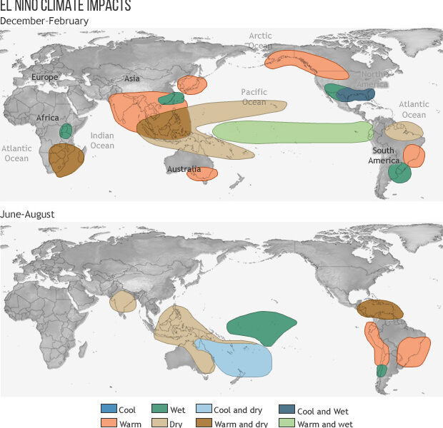
Both outcomes can occur in different places. El Niño tends to alter the jet stream and the average track of storms. Some regions can become wetter while remaining warm enough that much of the precipitation falls as rain. A few isolated snowstorms can also occur in a winter that is warmer than normal overall. Neither an El Niño strength probability nor an above-normal precipitation percentage tells you how many inches of snow to expect in Denver, Chicago, New York or Atlanta.
Why strong El Niño does not guarantee record snow
Even the biggest El Niño events differ. NOAA notes that the present pattern includes a negative Pacific Decadal Oscillation (PDO), unlike several famous past strong El Niños, which complicates one-to-one comparisons with 1982–83, 1997–98 or 2015–16. Other circulation patterns, including the Arctic Oscillation, can temporarily change how cold air reaches a region. The resulting interaction cannot be reduced to a single national snow prediction.
How are snow and precipitation forecasts different?
A seasonal precipitation outlook gives probabilities that a three-month total will finish above, near or below a historical average. It does not distinguish rain from sleet or snow. A snowfall forecast attempts to estimate snow specifically and needs shorter-range knowledge of temperatures, moisture, storm tracks and snow-to-liquid ratios. Any chart assigning exact months-away totals to dozens of U.S. cities should disclose that its precision is highly speculative.
Which U.S. areas could see more winter storms?
CPC guidance identifies increased odds of above-normal precipitation during parts of winter across California, the Southwest, the southern Plains, the Gulf Coast, the Southeast and portions of the Atlantic coastal corridor. In the mountains of California or the southern Rockies, an active storm track can translate into meaningful snow when temperatures cooperate. At lower elevations in the Gulf Coast and Southeast, the same wet signal chiefly raises expectations for rain.
For the northern states, a somewhat warmer average does not eliminate the possibility of disruptive blizzards. A single cold week can produce major local impacts even when the three-month average ends up warmer than the 1991–2020 baseline used by NOAA.
When does NOAA release the next winter outlook?
NOAA CPC says its next scheduled monthly long-lead seasonal outlook is Thursday, October 15, 2026. An ENSO diagnostic update may appear separately sooner; it should not be confused with a fresh full U.S. winter snowfall map. Readers can check the official seasonal outlook maps to distinguish valid periods such as December–January–February (DJF) from October–November–December (OND).
What should households and travelers do with this forecast?
- Mountain and ski travel: Track resort-specific snow, freezing levels and road conditions when your travel dates move into the reliable forecast window.
- Road trips: Monitor National Weather Service winter weather alerts a few days before departure rather than treating a national seasonal map as a route forecast.
- Flood-prone locations: In wetter-favored southern and coastal areas, prepare for heavy rain as well as the less common possibility of snow or ice.
- Home heating and supplies: Plan for normal seasonal risks; above-normal winter-average warmth does not preclude brief severe cold.
For other 2026 climate reporting, see our Arctic sea ice 2026 analysis. Travelers visiting Europe this autumn may also need the ETIAS 2026 status guide; it is separate from U.S. weather forecasting.
Frequently asked questions
Will winter 2026–27 be the snowiest in decades?
There is no credible basis as of October 8 to guarantee a record national or local snowfall total. NOAA’s latest guidance favors a very strong El Niño and regional precipitation/temperature patterns, not specific accumulation totals.
Is Texas expected to get snow this winter?
NOAA favors a wetter signal in parts of the southern Plains, but much of that precipitation can be rain. Snow in Texas depends on cold outbreaks and storm-scale details that cannot currently be pinned down for the season.
Does a warmer forecast mean no blizzards?
No. Seasonal averages describe the balance across months. Significant cold snaps or individual winter storms remain possible even in a statistically warmer-than-average season.
Is the October 7 NOAA report the official winter snow forecast?
No. The October 7 GFDL update discusses experimental El Niño predictions. CPC’s full seasonal temperature and precipitation outlook was last issued September 17, with the next update scheduled for October 15.
When will city-specific snow forecasts become reliable?
Snowfall estimates become more useful when an identifiable winter storm is within a shorter-range weather forecast window, usually days rather than months away. Check local NWS updates at that point.
Sources and editorial note
Checked October 8, 2026: NOAA CPC’s September 17 long-lead outlook and discussion, NOAA GFDL’s October 7 experimental ENSO prediction, and official seasonal outlook maps. This article does not claim access to unissued October 15 maps or exact snowfall accumulations.
Featured map: general El Niño winter effects, NOAA Climate.gov (public domain), Wikimedia Commons. The map is an educational climatology illustration, not a current 2026–27 forecast.